Creating Smart Rail Services Using Digital Technologies
Interactive Digital Signage for Better Passenger Information Services
Japan’s growing foreign tourism market is making it increasingly important for public transport providers to augment public transport information services for foreign visitors to the country. This article outlines the service requirements needed on traffic flows leading to airports, stations, and hotels (which are the major traffic flows used by foreign tourists in Japan), and summarizes the configuration of systems used to provide public transport information to foreign tourists. Also presented are two Hitachi system implementation examples created for Narita International Airport Corporation—Digital Integrated Transport Information Signage and infotouch. The latter is an interactive information display system that provides comprehensive handling of airport facility and store information, flight information, and ground transport information. A discussion of the future outlook for this area is provided at the end of this article.


Japan's government is focusing on foreign tourism as an industry that will help sustain the country in the years ahead. It has created an action plan called the 2018 Tourism Vision Realization Program(1). The plan is one of several measures being implemented to increase the number of foreign visitors to the country. Some 40 million foreign visitors are targeted for 2020, accounting for total travel spending of 8 trillion yen.
The number of foreign visitors to Japan has been rising steadily in recent years, with the figure reaching 28.69 million in 2017 (up 19.3% from the previous year). The country is responding to this market growth by taking steps to create an environment that will enable stress-free and comfortable travel for foreign tourists. One example is a project to help create public transport services and travel environments through both hardware and software elements. The software is designed to provide multilingual support along with public transport and transfer information.
Rail service operators are taking various steps to create an environment that will provide public transport service information tailored to foreign tourists. Personal accommodative measures are being improved by augmenting information counters for foreigners and providing multilingual translation tablets for station staff. Information and communication technology (ICT) is also being used to improve multilingual services, such as by creating multilingual versions of smartphone apps, guidance, and other displays.
Measures to accommodate foreign tourists are already abundant at Japan's international airports, where flight information and other information services are available. The airports are now adding to these measures by providing foreign tourists with a better lineup of information about non-airport services, in areas such as domestic transport and tourism.
A questionnaire survey on the use of public transport in the Tokyo area (carried out by Mitsubishi UFJ Research and Consulting in June 2014)(2) found that most foreign visitors to Japan were very satisfied with the punctuality and safety of the trains, but that some complained of having difficulty understanding route information to destinations, transfer methods, and exit information. The difficulties that foreign visitors encounter when using public transport in Japan may be caused by the language barrier and the difficulty of understanding the intricacies of a public transport network that encompasses many different operators including JR and public/private railway companies. Solving this issue requires information to be provided in a unified manner for many different transport service operators and outside services.
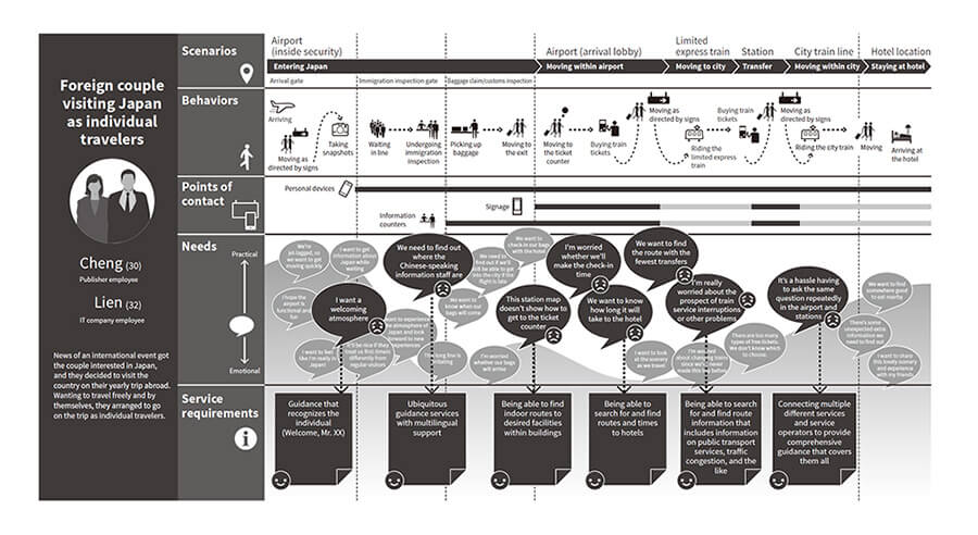
To conceptualize systems providing public transport information to foreign tourists, Hitachi has formulated service requirements by creating customer journey maps that trace the traffic flows of foreign tourists. Figure 1 shows an example customer journey map (excerpt) for typical traffic flows. It shows the major traffic flows used by foreign tourists to the airport, stations and hotels.
Customer journey maps are used mainly in the field of marketing. They provide a graphical representation of a customer's behavior, thoughts, and emotional processes starting from when they become aware of a product or service, until ultimately making a purchase. The tourists depicted by the example in Figure 1 are a foreign couple visiting Japan as individual travelers (a type of visitor recently on the rise). The diagram outlines their guidance needs and service requirements from their behavior, thoughts, and emotional processes at typical points (airports, stations, and hotels) located among a series of traffic flows between their arrival at the airport and their destination. The flow of scenarios is as follows: After arriving at the airport, they move through the airport, board a limited express train, transfer to a city train at a major station, then proceed to their hotel. Mapping the behaviors, points of contact, and needs they experience over this time onto a series of journeys has enabled the formulation of the following service requirements for systems that provide public transport information to foreign tourists:
Figure 1—Example Customer Journey Map (Excerpt) for Foreign Tourist Traffic Flows The diagram maps and formulates tourist guidance needs and service requirements on a series of journeys from the typical traffic flows of foreign visitors to Japan (airports, stations, and hotels).
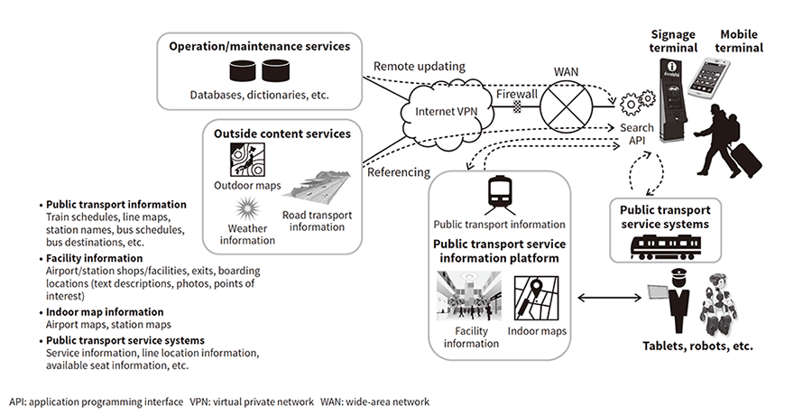
Figure 2 shows the configuration of a system that provides public transport information to foreign tourists. The system has been designed for the service requirements outlined in Section 2. It uses interactive signage terminals and mobile terminals (smartphones) as operation devices that let users enter their hotel or other destination information. In response to the information entered by the user, the search process application programming interface (API) in the device searches on the network to retrieve the required information from among public transport information, facility information, and indoor map information managed on a public transport service information platform. The search results provide transfer route information spanning multiple public transport service operators, required times, and information about routes within station facilities to ticket counters and boarding locations.
Information that is not on the public transport service information platform (such as outdoor map information and weather information) is obtained over the Internet from outside content services. It is used together with information retrieved from searches of indoor route information, public transport routes, and outdoor routes to enable seamless travel from the current location to the destination. It can also be used with real-time data such as public transport service information to enable service suspension and delay information to be added to public transport route search results in the future.
Searches can be entered with multilingual support for text or speech input. User operation and search histories can be stored on a guidance history database on the public transport service information platform to enable analysis of usage conditions and shared use of guidance information involving multiple public transport service operators. Database data and dictionaries can be updated remotely over the Internet. In the future, it will be possible to share information with devices such as staff tablets or guidance robots by using a system connection interface to connect the system to business systems.
Figure 2—Configuration of Systems Providing Public Transport Information to Foreign Tourists Interactive signage terminals and mobile terminals (smartphones) are used as the operation devices. The required information is displayed on the user’s device after being obtained over a network by a search processing API in the device. The API retrieves the information from among public transport, facility, indoor map and similar information managed on a public transport service information platform.
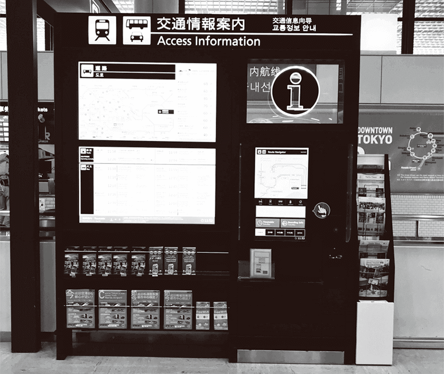
Figure 3—Digital Integrated Transport Information Signage This signboard can display transport information in the form of train route maps, train service conditions, departure times, bus departure times, and highway conditions. It can also print route search results and send information to smartphones.
Figure 4—infotouch Kiosk This kiosk can provide arriving/departing flight information for the current day, and guide users to locations such as check-in counters, boarding gates, the arrival lobby, and airport shops, restaurants, or other facilities. It can also provide information on public transport routes from the airport to hotels.
To present examples of systems providing public transport information to foreign tourists as described in the previous section, this section looks at two system implementation examples that Hitachi has delivered to Narita International Airport Corporation (NAA).
Signage created at Narita Airport in October 2017. Both infotouch and the system described above are designed to provide information about arrival traffic flows, but infotouch also provides information about departure and transfer traffic flows. It provides a comprehensive set of information on airport facilities and shops inside/outside security, and on flights and ground transport. It was created with the aim of improving the convenience of foreign visitors to Japan and other airport users (see Figure 4).
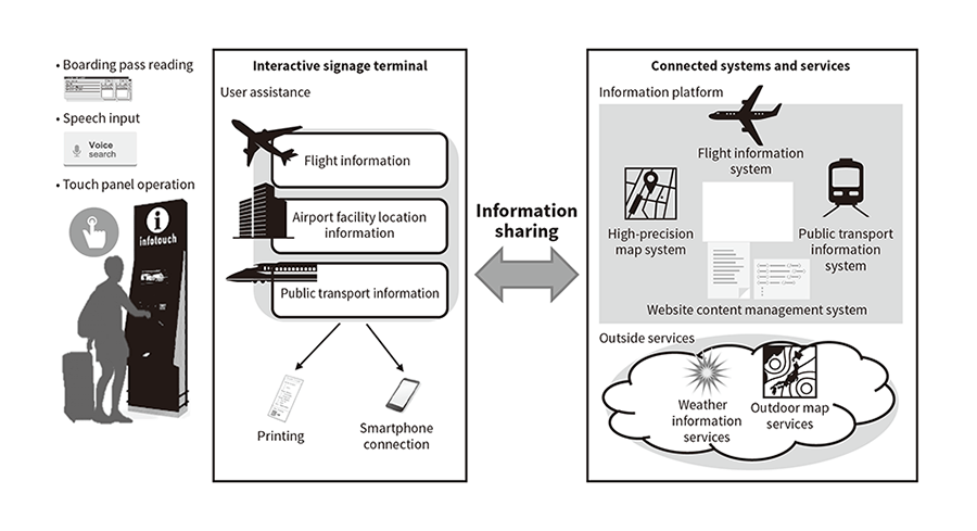
The infotouch system works together with the airport's internal flight information system, a website content management system, the airport's internal high-precision map system, and a public transport information system. It can provide flight information for the day's arrivals and departures, directions to check-in counters, boarding gates, the arrivals lobby, and airport shops, restaurants, or other facilities, along with information on routes from the airport to hotels using public transport. It also has a video call function that lets users talk to airport staff using the receiver and camera provided in the case of signage without having to go to an information counter.
To provide multilingual support, infotouch can input, output, and print text in nine languages. It supports spoken keyword searches in four languages, and has a search function that infers the intended meaning from simple spoken-phrase input. It also has functions designed specifically for airport use, such as reading boarding passes to retrieve arriving/departing flight information for the current day, and guiding users directly to boarding gates (see Figure 5).
The system currently averages about 286 users per day (as of March 2018), with about 15 users per hour at peak times. Newly arrived passengers sometimes queue to use the kiosks, attesting to the high demand for them (see Figure 6). On the kiosks installed in the airport's Satellite 5 area (inside security), about 35% of the requested information is about flights and about 65% is about airport facilities. On the kiosks installed in the arrival lobby's Visitor Service Center (outside security), about 15% of the requested information is about flights, about 25% is about ground transport, and about 60% is about airport stores and facilities. The most commonly searched facilities are automated teller machines, wireless local-area network (LAN) service counters, and Japan Rail Pass exchange points, demonstrating the demand for information about services needed while staying in Japan.
Figure 5—Overview of infotouch System Functions The infotouch system connects with an information platform including components such as a flight information system, high-precision map system, website content management system, and public transport information system. System kiosks provide users with information and guidance on flights, airport facility locations, and public transport. They support touch panel operation and speech input, and can read boarding passes.
Narita Airport is an entryway to Japan in the traffic flows of many foreign tourists. Creating systems that provide information to foreign tourists here has provided knowledge about information demands. Hitachi plans to implement systems with the following aims: To provide seamless guidance to users by developing systems that provide public transport information on foreign tourist traffic flows from points of origin (airports) to midpoints and end points (railway stations). And, to improve the guidance services of public transport service operators by serving as comprehensive information provider systems that work in conjunction with connected outside services and public transport business systems.