Solutions Based on Measurement Technology
The Society 5.0 initiative has been pursued jointly by the Japanese government and industry to create a “super smart society” through the use of data and the latest science and technology to overcome social challenges such as labor shortages due to Japan’s aging population and low birth rate. Accordingly, as more precise position information has attracted attention as a solution for social issues, particularly represented by mobility, the commercialization of global correction message distribution services that enable highly precise satellite positioning is being promoted. This article presents an overview of high-precision satellite positioning technology and describes a demonstration experiment in Australia in which Hitachi played a key role.


Japan faces a wide variety of societal challenges, including labor shortages resulting from its aging population and low birth rate, the welfare and care of the elderly, the depopulation of rural cities and limits on maintaining public transportation, the declining rate of food self-sufficiency, and the increasing frequency of major natural disasters due to abnormal weather events. Meanwhile, joint initiatives involving the public and private sectors working together are being undertaken to address these societal challenges.
This article looks first at ongoing digitalization and, within this trend, the role that high-precision positioning information plays in overcoming societal challenges in Chapter 2. In Chapter 3, describes the fields where high-precision positioning information is expected to be used and the requirements for precise satellite positioning. This is followed by Chapter 4, which takes a look at what is happening with the satellite positioning systems operated by different countries and the latest techniques they are using, including a service that distributes correction messages on positioning. In Chapter 5, two preliminary examples of this technology are described involving, respectively, a trial in which high-precision satellite positioning is used for an automated tractor and another in which a drone is used for high-precision agricultural land sensing. Lastly, Chapter 6 summarizes all of the content above.
The Society 5.0(1) initiative, being pursued jointly by the government and industry in Japan, has been driven to create a “super smart society” through the use of data and the latest science and technology to resolve societal challenges. Typical examples of these challenges include the labor shortages resulting from its rapidly aging population and low birth rate, and the challenge of maintaining and improving productivity. This chapter describes the roles played by highly precise positioning information in this trend and in overcoming societal challenges.
The world is entering a new era of industrial development and societal change driven by advances in digital technologies such as big data analytics, artificial intelligence (AI), and robotics, and also by the expanding reach of the Internet of Things (IoT) that is connecting many different types of things to the internet.
The optimization and streamlining of each part of the value chain have been sought so far by making use of digital technologies, especially in the industry sector. However, the current trend of digitalization is bringing optimization and efficiency improvements to every last corner of the value chain, or creating new solutions and services that have never existed before. Rather than just boosting the efficiency of individual businesses, this trend also carries with it the potential to transform all aspects of society, from the structure of industry to personal lifestyles.
Realizing the “super smart society” requires a high-level fusion of cyberspace and physical space. Of particular importance to achieving this is the sensing of the “what, where, and when” of events in physical space with high precision. If imprecise sensing information is used, the accuracy of analysis and prediction by big data analytics and AI in cyberspace are also impaired. Imprecise analysis and prediction in turn mean that the data provided back to the physical world also become inaccurate, impeding the appropriate control of people, goods, and things in physical space (see Figure 1).
Satellite positioning, as exemplified by the US Global Positioning System (GPS), is expected as a means to provide sensing of “where” and “when” in outdoor physical spaces with high precision. As the satellites used for satellite positioning are equipped with atomic clocks, the information they provide includes highly precise time information. Another feature of satellite positioning is that it provides an absolute position on the Earth.
Figure 1—Role of High-precision Positioning Information in Overcoming Societal Challenges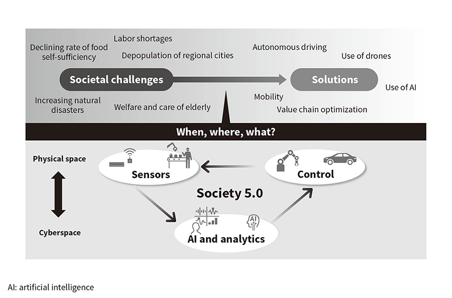 Highly precise information about the what, where, and when of events, is vital to resolving societal challenges.
This chapter introduces fields and applications where high-precision positioning information is expected to be used, and the requirements for precise satellite positioning.
The control of mobility services is one application that requires a particularly high level of outdoor positioning precision. Advances in mobility, such as automobiles, boats, agricultural machinery, construction machinery, and drones, have made it easier for people and things to move around, resulting in major progress in society through labor savings and higher productivity. Amid demand for dramatic improvements in productivity and the enhancement of public safety and security, recent years have also seen an acceleration in moves that seek to shift from mobility controlled by people to mobility control and automation by machines.
Highly precise absolute position information is vital for controlling mobility services. In the case of autonomous driving, for example, control systems have been developed that combine precise satellite positioning with relative positioning technologies such as cameras or light detection and ranging (LiDAR).
High-precision absolute position information has potential uses in a variety of applications. Possibilities in the automotive and transportation sectors, for example, include the use of autonomous driving in vehicles such as private cars, taxis, buses, and trucks to resolve labor shortages, reduce traffic accidents, and provide on-demand transportation, or the use of lane recognition to reduce congestion by operating navigation on a lane-by-lane basis. In marine transportation, possibilities include automatic navigation and collision avoidance in shallow or inshore waters or in locations through which large numbers of vessels pass, or cost and energy savings achieved by selecting optimal courses. Potential agricultural applications include automated tractors to overcome labor shortages, to keep operating through the night during busy times of year, or to avoid the effect of coming natural disasters, and labor savings from the use of drones capable of highly precise land sensing to monitor for crop growth or for pests or weeds. In construction, the opportunities are for labor savings, accident reduction, and faster completion of work through the autonomous operation of construction machinery. Potential applications also exist in many other areas such as logistics, infrastructure inspection, and civil defense.
Key requirements for high-precision satellite positioning in the above-mentioned applications are as follows.
Satellite positioning systems have been established and operated by different countries around the world. This chapter introduces the trends in satellite positioning systems in different countries and the latest technologies for high-precision satellite positioning that have attracted interest in recent years.
As a trend of satellite positioning systems that are generally called Global navigation satellite system (GNSS) in individual countries. The USA and the Russian Federation have operated their GPS and Global Navigation Satellite System (GLONASS) systems, respectively, since the 1960s and are driving their systems' modernization now(2).
In recent years, the European Union (with Galileo) and China (with BeiDou) have also been establishing and operating their own satellite positioning systems, with both scheduled to go into full operation in 2020 with 30 satellites each.
Japan, meanwhile, has built its own quasi-zenith satellite system (QZSS) called Michibiki, which functions as a regional navigation satellite system (RNSS) for Asia and Oceania. The plan is to establish a separate satellite positioning system specifically for these regions. Michibiki commenced initial operation in November 2018 with four satellites, and will expand to seven satellites by 2023.
Based on the assumption that the satellite orbits (current locations) are known, satellite positioning works on the principle of triangulation to identify the position of a receiver (code positioning), with a ground station receiving signals (“codes”) from each satellite and calculating the distance in between based on the differences in code arrival time. The GNSS receivers in car navigation systems and smartphones work according to this principle and have error deviations between several meters and several tens of meters.
In surveying, however, where precision of a few centimeters is required, the receivers instead use carrier phase positioning whereby the phases of the carrier waves are used rather than the code arrival time differences to calculate the distance to the satellites, thereby achieving much higher precision. Unfortunately, satellite positioning is subject to errors in the satellite's orbit and clock, the influence of the troposphere and ionosphere, and the error in the receiver's clock. In order to reduce these errors, a reference station (receiver) is located in a place with an accurate location that is known near a mobile station (receiver), and the measurement data of the reference station is provided to the mobile station so as to lower the errors to within a few centimeters. This technique is typically called real-time kinematic (RTK) positioning. Furthermore, Japan has about 1,300 electronic reference points nationwide for monitoring movements of the Earth's crust. One more technique is network RTK, which makes use of the above information to create virtual reference points in locations that lack a real one to calculate corrections and forward them to the mobile stations.
Similarly to surveying, control of mobility services also requires precision with an error deviation of a few centimeters. However, since the use of RTK or network RTK in broad areas requires a number of reference points to be installed, precision with error deviations of a few centimeters become available only within 20 to 30 km around these points. Furthermore, to improve their positioning precision, receivers that use RTK are larger than those used in devices such as car navigation systems, and very costly. Due to these circumstances, there are issues to be solved for the use to control mobility.
Figure 2—MADOCA Positioning Augmentation Service MADOCA generates and distributes correction messages for high-precision satellite positioning from observation data obtained from global monitoring stations.
A new high-precision positioning technique that has attracted interest in recent years is precise point positioning (PPP)(3). Whereas satellite positioning is subject to errors in the satellite's orbit and clock, as explained above, PPP works by estimating precise orbits and clock errors and providing this information to mobile stations, thereby allowing a mobile station's receiver to achieve precise positioning on its own without installing reference stations.
Recognizing that satellite orbit tracking can be used for the precise orbit and clock estimation needed in PPP, the Japan Aerospace Exploration Agency (JAXA) developed the Multi-GNSS Advanced Demonstration Tool for Orbit and Clock Analysis (MADOCA)(4). MADOCA generates correction messages (which include precise satellite orbits and clock error corrections) based on observational data from about 100 satellite tracking stations around the world and passes these to mobile stations via satellite or the Internet (see Figure 2).
MADOCA can provide highly precise absolute positioning with an error deviation of a few centimeters anywhere in the world, including at sea or in remote locations with very fewer stations than RTK. Also, it can be easily incorporated into existing systems and applications thanks to its affinity with existing carrier positioning.
Global Positioning Augmentation Service Corporation(5), which has a service for distributing correction messages to perform high-precision satellite positioning globally using the MADOCA technique described above, was established on June 15, 2017 jointly by Hitachi Zosen Corporation, Development Bank of Japan Inc., Denso Corporation, Hitachi Automotive Systems, Ltd., and Japan Radio Co., Ltd. Later, NEC Solution Innovators, Ltd., Furuno Electric Co., Ltd., Toyota Tsusho Corporation, and Magellan Systems Japan, Inc. also provided investments. Currently, with the aim of starting commercial service from FY2020, the company is working on activities such as technology demonstrations by distributing test signals. The company also has maintained environments that allow a variety of receiver manufacturers and system vendors to use their service by making the correction message data format open.
The Hitachi Group has undertaken automated tractors and high-precision agricultural land sensing with drones in Australia in order to demonstrate how high-precision satellite positioning can be used for mobility control, etc.
Hitachi was commissioned by the Ministry of Internal Affairs and Communications (MIC) in FY2016 to undertake the “contract for an examination of a highly efficient farm work system that uses a quasi-zenith satellite augmentation signal for agriculture in Australia.”
The project was intended to contribute to the realization of efficient farm work by fitting a MADOCA-capable GNSS receiver to a tractor so that it can operate autonomously. Demonstrations took place in October and December 2016 in Australia, at a sugarcane plantation in Mackay, Queensland. The project partners included Hitachi, Hitachi Zosen Corporation, Hitachi Solutions, Ltd., Hokkaido University, Yanmar Holdings Co., Ltd., and Hitachi Australia Pty Ltd.
The demonstration involved an automated tractor that performed soil preparation, furrowing, watering, and fertilizer spreading. The responses from farmer interviews indicated that up to about 80% of these tasks can be automated. It is also estimated that this would cut annual labor costs by $A175 per hectare (10,000 m2). Given that the average farm size in Australia is 3,000 hectares(6), this corresponds to annual savings of $A525,000. Also, as autonomous driving allows for night work, unlike human operators, effects such as work time reduction can be expected. The demonstration proved that the automation of agricultural machinery such as tractors with precise satellite positioning can contribute to efficient farm work (see Figure 3).
The positioning precision of the MADOCA technique during this demonstration was 7.5 cm (RMS: Root Mean Square) horizontally and 8.7 cm (RMS) vertically relative to the RTK positioning results. While the precision required for the process in this experimental demonstration was sufficient, the feedback from farmers was that even greater positioning precision and reliability are needed for some crops and tasks. In addition, the positioning took about 30 minutes before being stabilized to a few centimeters after turning on the GNSS receiver. Although the effect is small as the positioning is stabilized during preparation in the event of warm work, improvements are required depending on fields and applications.
When it comes to the above-mentioned issue, Global Positioning Augmentation Service Corporation, referred to in section 4.3, is working on improving the algorithm, including making improvements and generating correction messages by establishing local reference points.
Figure 3—Demonstration of Highly Efficient Farming System Using Quasi-zenith Satellite Augmentation Signals for Agriculture in Australia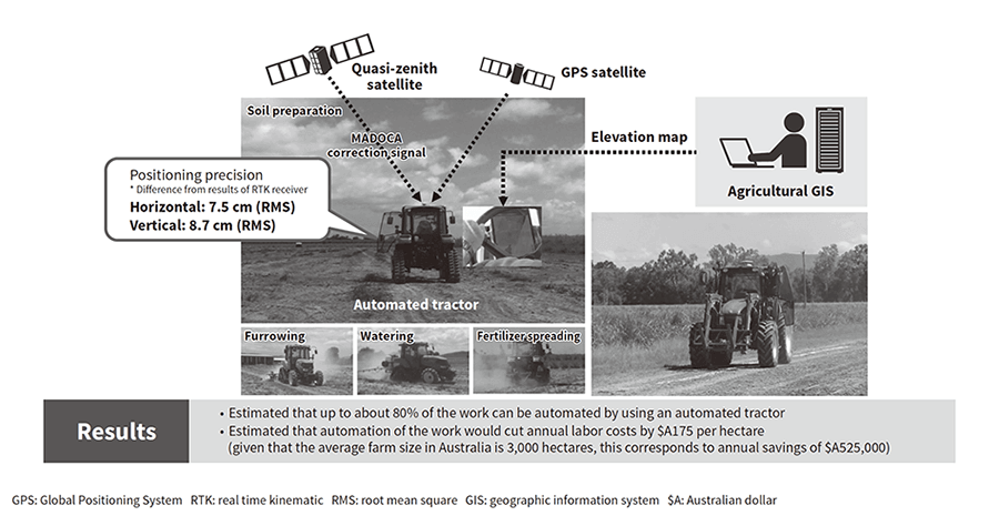 The demonstration was intended to contribute to efficient farming by fitting a MADOCA-capable GNSS receiver to a tractor so that it can operate autonomously.
Hitachi was commissioned by the MIC in FY2017 to undertake the “contract for an examination of a high-precision, high-efficiency analytical system that uses a quasi-zenith satellite for agriculture in Australia.”
The project, carried out in February 2018 at a banana plantation in Carnarvon, Western Australia, was intended to contribute to efficient farm work by fitting a MADOCA-capable GNSS receiver and multi-spectrum camera to a drone for the high-precision sensing and analysis of farmland. The project partners included Hitachi, Hitachi Solutions, Ltd., Hitachi Industrial Equipment Systems Co., Ltd., Hitachi Australia Pty Ltd., and Global Positioning Augmentation Service Corporation.
The demonstration carried out high-precision sensing of the banana plantation using drones and extracted weeds in the plantation by analyzing multi-spectrum images. The results indicated that 81% (0% false recognition rate) of the weeds in the 0.5-hectare area analyzed (excluding around the base of trees) could be extracted. Furthermore, 92% (0% false recognition rate) of the weeds with a diameter of 10 cm or more to be sprayed with herbicide were extracted. Meanwhile, interviews with farmers and agricultural consultants obtained an estimated 207-hour reduction in land inspections per year if the system is installed at large banana plantations of 15 hectares or more. This demonstrated that a combination of precise satellite positioning, multi-spectrum sensors, drones, and image analysis techniques can contribute to more efficient farm work (see Figure 4).
The positioning precision of the MADOCA technique during this demonstration was 5.5 cm (RMS) horizontally and 4.5 cm (RMS) vertically relative to the RTK positioning results, showing higher positioning precision than the previous fiscal year's demonstration in Australia. Furthermore, when it comes to the position stabilization time, it still remains an issue, but improvements are ongoing as described in section 5.1.
Figure 4—Demonstration of High-precision and High-efficiency Analytical System Using Quasi-zenith Satellites for Agriculture in Australia The demonstration proved it could contribute to efficient farm work by fitting a MADOCA-capable GNSS receiver and multi-spectrum camera to a drone and using it for the high-precision sensing and analysis of farmland.
Technology continues to advance at a breathtaking pace, bringing numerous benefits to work and daily life. Making precise satellite positioning available throughout the world at low cost has the potential to give rise to new solutions and services that are not presently on offer. For example, solutions and services including robots that automatically inspect social infrastructure and replace it before it deteriorates can be expected.
The Hitachi Group intends to develop technologies and products and create solutions and services for making use of high-precision satellite positioning in coordination with a variety of stakeholders, in order to contribute to solving societal challenges from the perspective of mobility.
This article includes the results from “FY2016 contract for an examination of a highly efficient farm work system that uses a quasi-zenith satellite augmentation signal for agriculture in Australia” and the “FY2017 contract for an examination of a high-precision, high-efficiency analytical system that uses a quasi-zenith satellite for agriculture in Australia,” both commissioned by the MIC.