Featured customer case
Lumada customer case code: UC-01940S
—TRAFFICSS: A traffic flow simulator supporting road projects and urban development—
2023-09-20
For road projects to proceed in a steady manner, it is important for local residents to correctly understand the project plans. If project planners can simulate various traffic states and road conditions in cyberspace and can visually show images of the situation after the project is complete, the planners can show the project’s benefits in an easy‑to‑understand manner.
This paper describes a customer case in which planners can formulate project plans based on the results of simulations in cyberspace. The planners can generate images and animations of the future streets and neighborhoods, and can use these to explain a project’s benefits to residents.
The real‑estate construction business can also utilize the technology that uses digital twins to perform simulations in cyberspace.
For the construction of a large‑scale facility where many people and vehicles gather, project planners can use this technology to simulate traffic conditions such as congestion and to explain the situation to local residents. By incorporating opinions and requests for desired changes, planners can ensure the project advances smoothly with the participation of residents while reducing the adverse impact on surrounding roads.
In addition, eliminating traffic congestion has a positive impact not only on the natural environment but also on the movement of goods and materials, so stakeholders can expect increased economic benefits in the region.
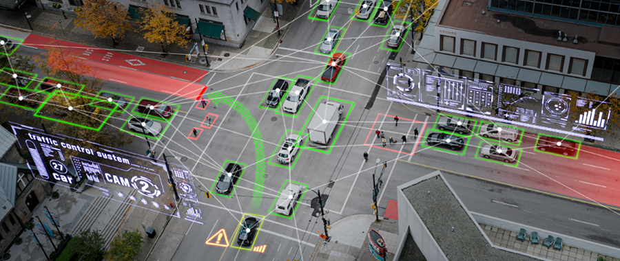
Co‑creation with Lumada! Visual representations of simulation results
Roads are the most familiar social infrastructure for people. Roads not only function to connect people and communities, but also shape the environment and landscape of the city, ensure smooth economic activities, and help provide safety in the event of a disaster.
Current society faces many different problems such as a declining birthrate with an aging population, depopulation in rural areas, and the increasing frequency of natural disasters. In this situation, road projects are essential to create cities where everyone can live comfortably. However, even if planners try to promote a road project, in many cases the project does not progress smoothly because the planners could not obtain the understanding and approval of the local residents.
In a large‑scale road project, obtaining the understanding and approval of local residents is essential for the project to proceed according to schedule, but local residents need to understand a wide range of information.
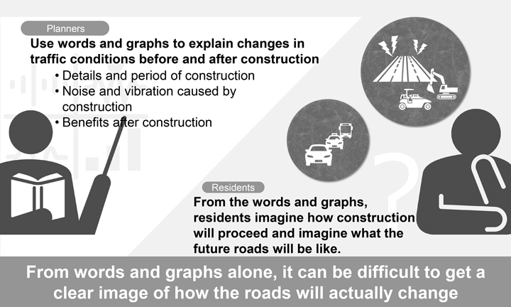
Residents need information about issues that will greatly impact their daily lives: for example, details of the road construction, its duration, and how much noise and vibration it will generate. In addition, in order to convince people that a project will provide long‑term benefits, despite some short‑term inconvenience, project planners must carefully explain the benefits such as alleviation of traffic congestion, improvements in pedestrian safety, and the provision of evacuation routes if a disaster occurs.
However, even if planners verbally explain that Traffic flow will be smoother and Pedestrians can walk safely, or if they use graphs to show the changes in traffic conditions before and after construction, local residents often have difficulty in visualizing what the road or neighborhood will look like in the future, and it is difficult for them to get a deep understanding of the future situation.
If stakeholders can view how the movement of vehicles and people will change after a project is complete and can view the actual traffic movements, the stakeholders will intuitively understand the business benefits.
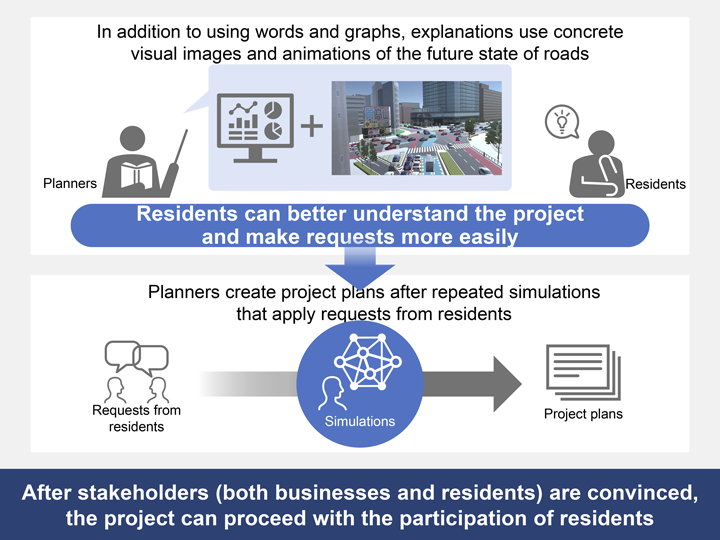
By utilizing Hitachi’s simulation technology and using the generated images and animations to show the simulated future results, stakeholders can visually confirm the business benefits.
The simulations utilize digital twins, which exactly replicate real‑world road conditions in cyberspace. A project plan contains many details for which it is difficult to conduct experiments on actual roads, such as for multi‑layered intersections. Using digital twins, however, planners can repeat simulations over and over again while changing various conditions.
Using a digital twin to show the streets and neighborhood after the project is complete (which is impossible to do in the real world), planners can create animations that clearly show how people and cars will move in the future. By using animations in addition to quantitative information such as graphs when they explain a project to residents, planners can ensure that residents visually understand the project’s benefits.
As their understanding of a project plan improves, local residents are likely to submit more specific questions and requests. Planners can incorporate such questions and requests into their scenarios and simulate the movement of people and vehicles by using digital twins, so the planners can formulate project plans based on the agreement of both businesses and residents.
As a result, the project can proceed with the participation of residents. This in turn reduces the number of complaints that arise after construction starts.
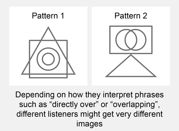
What kind of diagram comes to mind when you hear the following description?
“A rectangle is directly over a triangle, and the rectangle contains two overlapping circles.”
Listeners who draw images based on what they heard can produce very different diagrams, as shown on the left. Even if you use the same words to describe the same situation, different listeners might form different mental images.
To accurately convey information and align perceptions, it is important to show specific, visually understandable images. By allowing the audience to visually confirm the images they have in their heads, you can prevent misunderstandings even if what you want to convey becomes complex.
When proceeding with road projects and urban development, explanations using diagrams, illustrations, animations, etc. help project planners convey information more accurately.
Simulations and easy‑to‑understand explanations to residents are indispensable if road projects are to proceed smoothly.
Next, we will introduce the functionality and features of Hitachi’s Lumada solution TRAFFICSS, which can achieve these goals.