Featured customer case
Lumada customer case code: UC-01940S
—TRAFFICSS: A traffic flow simulator supporting road projects and urban development—
2023-09-20
Trialing road projects and urban development in cyberspace
TRAFFICSS can simulate, in cyberspace, various traffic‑related events and conditions on roads and enables stakeholders to evaluate various proposals visually and quantitatively.
TRAFFICSS simulations utilize digital twins, which accurately represent real‑world traffic flows using data such as the results of traffic volume surveys.
Project planners can conduct simulations under various conditions for which it is difficult to conduct experiments on actual roads. For example, TRAFFICSS allows planners to change traffic‑signal times or to examine multi‑layered intersections.
In addition, TRAFFICSS supports traffic conditions that are common overseas, such as roundabouts and right‑hand traffic. Therefore, planners can conduct simulations of roads other than those in Japan. Planners can set detailed events and conditions (such as the behavior of individual vehicles, pedestrian behavior, whether there is on‑street parking, and buses at bus stops) and conduct simulations to check the impact on traffic flows. This process produces highly accurate results.
Planners can repeatedly conduct simulations under a wide variety of conditions and compare the results, resulting in an optimal project plan that provides the highest benefits.
Project planners can express the results of simulations quantitatively, in numerical values and graphs. In addition, the planners can apply the results onto paid and free maps, and can express the results visually in 2D and 3D animations.
In 2D animations, TRAFFICSS users can apply simulation results onto frequently used maps such as Google Earth and maps of the Geospatial Information Authority of Japan, and can check how objects such as cars move.
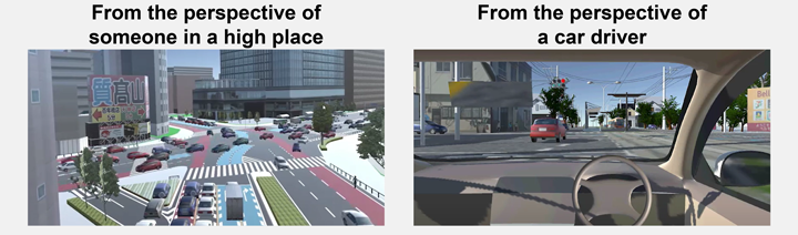
In 3D animations, TRAFFICSS users can apply simulation results onto 3D maps provided by ZENRIN CO., LTD. and PLATEAU*, etc. The users can express cityscapes including buildings around roads three‑dimensionally, and viewers can check traffic flows from a viewpoint that looks down from a high place. In addition, by combining the results with VR (virtual reality) technology, viewers can see the future streets and neighborhood after the project is complete from the perspective of a car driver who is actually driving on the street or a pedestrian walking in the neighborhood.
Animations enable viewers to understand the traffic flow as if they were actually in the neighborhood after the project is finished, which makes the situation easier for them to understand. The resulting presentation materials are effective in meetings among related parties and in explanations to residents.
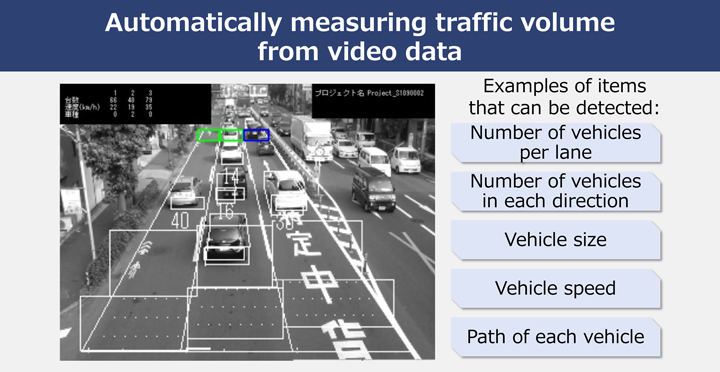
TRAFFICSS can improve the accuracy of measurement data used for simulations by linking with TRACOLRE, a solution that automatically measures traffic volume from video data.
When considering a project plan, planners usually conduct a traffic volume survey to understand the current situation related to the roads. Such traffic surveys are usually conducted manually, which results in the following problems:
To resolve such problems, Hitachi provides TRACOLRE, which can automatically measure traffic volume and traffic flows. By using TRACOLRE’s image recognition technology to detect vehicles in actual video footage of roads and then analyzing the vehicle sizes, number, speeds, paths, etc. over time, planners can understand the current situation more accurately.
TRACOLRE eliminates the problems of manual traffic surveys and enables highly accurate simulations. In addition, it shortens the time from understanding the current situation to conducting simulations.
Next, we will describe an actual example of using the described solutions to implement a new public transportation system in Utsunomiya City, which is in Japan’s Tochigi Prefecture. The project is constructing a next‑generation streetcar system called LRT (Light Rail Transit).
In Utsunomiya City, the percentage of people who use cars for transport is high; however, the percentage of people who cannot drive a car is increasing as the population ages. For Utsunomiya to be a city where it is easy to live, the city needs good public transport.
Therefore, Utsunomiya City decided to introduce LRT as their next‑generation streetcar system. This new public transport system will join the existing train and bus systems.
Our goal is to ensure the wide use of TRAFFICSS not only in road business but also in the formulation of project plans and construction plans in various industries.
For example, in the real estate construction business, TRAFFICSS will contribute to urban development by enabling the participation of residents, and by ensuring that the impact of facility construction on surrounding roads is taken into account.
When a large shopping center or a large‑scale logistics center is built, traffic congestion in the surrounding roads can be expected because, after construction, a large number of people and cars will be concentrated in one place. Using TRAFFICSS, project planners can simulate the traffic flow after the construction of the facility and formulate a construction plan that incorporates measures to alleviate traffic congestion. Furthermore, planners can perform re‑simulations that reflect the requests of local residents, and incorporate the results in the construction plan.
These solutions make it possible to promote real estate construction projects in which residents participate and which take into account the impact on surrounding roads. In addition, by simulating not only the traffic flow after the facility is constructed, but also the impact of the increase in the number of construction vehicles during construction, planners can reduce the entire project’s impact on surrounding roads.
Alleviating traffic congestion not only improves the environment by reducing the amount of exhaust gas, but also has a positive impact on the flow of goods and materials, which will increase economic benefits in the region.
For details on our solutions, see the following webpages.
The real‑estate construction business can also utilize the technology that uses digital twins to perform simulations in cyberspace.
For the construction of a large‑scale facility where many people and vehicles gather, project planners can use this technology to simulate traffic conditions such as congestion and to explain the situation to local residents. By incorporating opinions and requests for desired changes, planners can ensure the project advances smoothly with the participation of residents while reducing the adverse impact on surrounding roads.
In addition, eliminating traffic congestion has a positive impact not only on the natural environment but also on the movement of goods and materials, so stakeholders can expect increased economic benefits in the region.